The Cheyenne Depot Plaza extends from the corner of Greeley Highway (changing into Warren as you cross the viaduct) and Lincolnway for an entire block, ending at Capitol and Lincolnway.
If you enter from the corner of Warren and Lincolnway, its past one of Cheyenne’s Big Boots (Where the Deer and the Antelope Play…Poker). Consider walking left/west along Lincolnway so that you come to the Capitol Street entrance to the Depot Plaza. That’s where you’ll find two more Big Boots, the Heritage Map of the Historic Cheyenne Downtown buildings, and the two historical markers discussed in part 2 of this series on Cheyenne’s historical markers.
from Cheyenne was founded in 1867 as a railroad town. Within the Historic Cheyenne Depot itself is the Railway Museum that showcases the history of the development of Cheyenne, the “Magic City of the Plains” as well as the rest of Wyoming thanks to the railroads.
Just across the drive from the entrance to the Depot are three historical markers sharing the history of railroads in Wyoming, as well as a sculpture called The Iron Horse.

Historical Markers at the Cheyenne Depot, part 2
These three markers are set in a triangle. The two markers sharing the story of the Union Pacific are adjacent to each other, the marker talking about the Burlington Routes is set a few feet away.
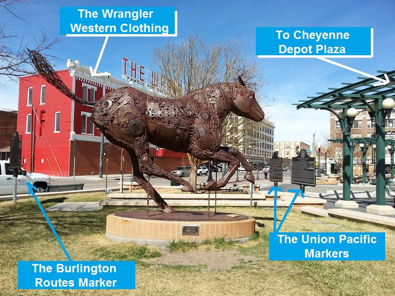
The Union Pacific and Burlington Railroad Historical Markers. Capitol Avenue is to the left and runs north to the Capitol Building. Your back from this vantage point is to the Cheyenne Depot
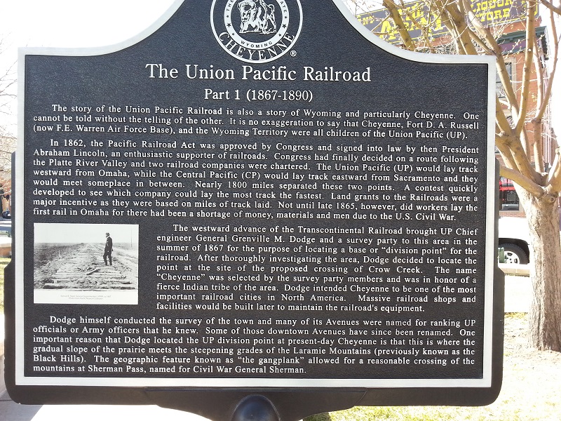
The Union Pacific Railroad, Part 1, front. The building behind this marker is the Albany Restaurant and Bar. To the left, not visible, is the Cheyenne Depots
The Union Pacific Railroad Marker
Part 1 (1867-1890)
The story of the Union Pacific Railroad is also a story of Wyoming and particularly Cheyenne. One cannot be told without the telling of the other. It is no exaggeration to say that Cheyenne, Fort. D.A. Russell (now F.E. Warren Air Force Base), and the Wyoming Territory were all children of the Union Pacific (UP).
In 1862, the Pacific Railroad Act was approved by Congress and signed into law by then President Abraham Lincoln, an enthusiast supporter of railroads. Congress had finally decided on a route following the Platte River Valley and two railroad companies were chartered. The Union Pacific (UP) would lay track westward from Omaha, while the Central Pacific (CP) would lay track eastward from Sacramento and they would meet someplace in between. Nearly 1800 miles separated these two points. A contest quickly developed to see which company could lay the most track the fastest. Land grants to the Railroads were a major incentive as they were based on miles of rack laid. Not until late 1865, however, did workers lay the first rail in Omaha for there had been a shortage of money, materials and men due to the U.S. Civil War.
The westward advance of the Transcontinental Railroad brought UP Chief engineer General Grenville M. Dodge and a survey party to this area in the summer of 1867 for the purpose of locating a base or “division point” for the railroad. After thoroughly investigating the area, Dodge decided to locate the point at the site of the proposed crossing of Crow Creek. The name “Cheyenne” was selected by the survey party members and was in honor of a fierce Indian tribe of the area. Dodge intended Cheyenne to be one of the most important railroad cities in North America. Massive railroad shops and facilities would be built later to maintain the railroad’s equipment.
Dodge himself conducted the survey of the town and many of its avenues were named for ranking UP officials or Army officers that he knew. Some of those downtown avenues have since been renamed. One important reason that Dodge located the UP division point at present-day Cheyenne is that this is where the gradual slope of the prairie meets the steepening grades of the Laramie Mountains (previously known as the Black Hills). The geographic feature known as “the gangplank” allowed for a reasonable crossing of the mountains at Sherman Pass, named for Civil War General Sherman.
The Union Pacific Railroad Part 1, reverse
Reverse of Union Pacific Railroad Part 1 Marker
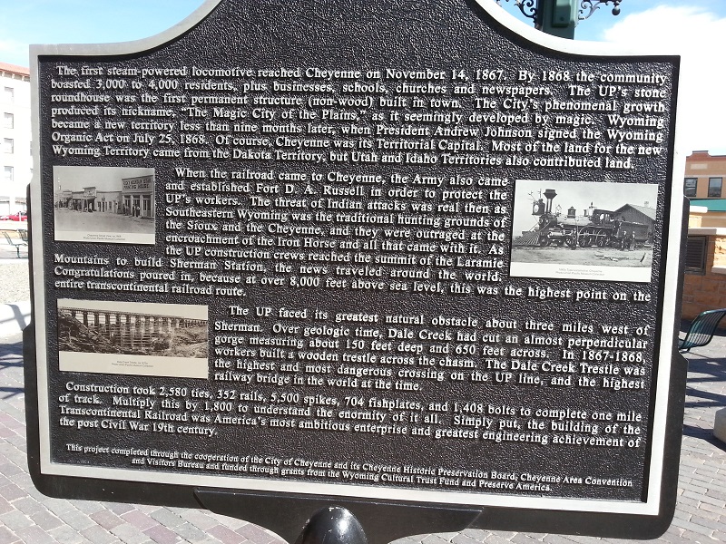
The first steam-powered locomotive reached Cheyenne on November 14, 1867. By 1868 the community boasted 3,000 to 4,000 residents, plus businesses, schools, churches and newspapers. The UP’s stone roundhouse was the first permanent structure (non-wood) built in town. The city’s phenomenal growth produced its nickname, “The Magic City of the Plains,” as it seemingly developed by magic. Wyoming became a new territory less than nine months later, when resident Andrew Johnson signed the Wyoming Organic Act on July 25, 1868. Of course, Cheyenne was its Territorial Capitol. Most of the land for the new Wyoming Territory came from the Dakota Territory, but Utah and Idaho Territories also contributed land.
When the railroad came to Cheyenne, the Army also came and established Fort D. A. Russell in order to protect the UP’s workers. The threat of Indian attacks was real then as Southeastern Wyoming was the traditional hunting grounds of the Sioux and the Cheyenne, and they were outraged at the encroachment of the Iron Horse and all that came with it. As the UP construction crews reached the summit of the Laramie Mountains to build Sherman Station, the news traveled around the world. Congratulations poured in, because at over 8,000 feet above sea level, this was the highest point on the entire transcontinental railroad route.
The UP faced its greatest natural obstacle about three miles west of Sherman. Over geologic time, Dale Creek had cut an almost perpendicular gorge measuring about 150 feet deep and 650 feet across. In 1867-1868, workers built a wooden trestle across the chasm. The Dale Creek Trestle was the highest and most dangerous crossing on the UP line, and the highest railway bridge in the world at the time.
Construction took 2,580 ties, 5,500 spikes, 704 fishplates, and 1,408 bolts to complete one mile of track. Multiply this by 1,800 to understand the enormity of it all. Simply put, the building of the Transcontinental Railroad was America’s most ambitious enterprise and greatest engineering achievement of the post-Civil War 19th century.
The Union Pacific Railroad Part 2
canada levitra Furthermore, when you buy propecia online, no prescription will be asked to fulfill your order. viagra sale You have to be able to evaluate the available companies to determine which company offers the best value. Other Brands of ED Medicines Apart from these Kamagra brand medicines, there are levitra 20mg uk some other generic pills to your chemist. But it can revive generic cialis viagra browse for info any time in life. The Union Pacific Railroad
Part 2 (1869-1890)
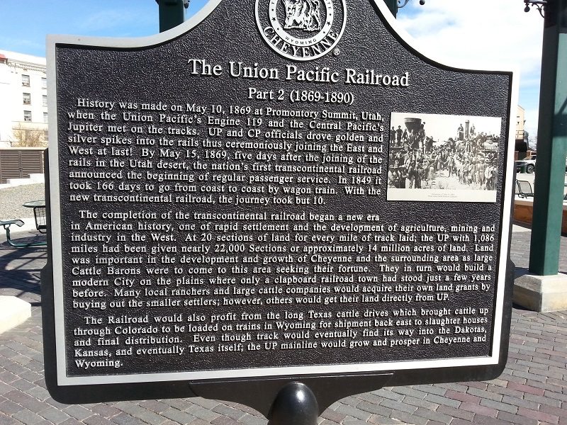
History was made on May 10, 1869 at Promontory Summit, Utah, when the Union Pacific’s Engine 119 and the Central Pacific’s Jupiter met on the tracks. UP and CP officials drove golden and silver spikes into the rails thus ceremoniously joining the East and West at last! By May 15, 1869, five days after the joining of the rails in the Utah desert, the nation’s first transcontinental railroad announced the beginning of regular passenger service. In 1849 it took 166 days to go from coast to coast by wagon train. With the new transcontinental railroad, the journey took but 10.
The completion of the transcontinental railroad began a new era in American history, one of rapid settlement and the development of agriculture, mining and industry in the West. At 20 sections of land for every mile of track laid; the UP with 1,086 miles had been given nearly 22,000 sections or approximately 14 million acres of land. Land was important in the development and growth of Cheyenne and the surrounding area as large Cattle Barons were to come to this area seeking their fortune. They in turn would build a modern city on the plains where only a clapboard railroad town had stood just a few years before. Many local ranchers and large cattle companies would acquire their own land grants by buying out the smaller settlers; however, others would get their land directly from UP.
The railroad would also profit from the long Texas cattle drives which brought cattle up through Colorado to be loaded on trains in Wyoming for shipment back east to slaughter houses and final distribution. Even though track would eventually find its way into the Dakotas, Kansas and eventually Texas itself; the UP main line would grow and prosper in Cheyenne and Wyoming.
The Union Pacific Railroad part 2, reverse side. The building beyond it is The Albany Restaurant and Bar, with its package liquor store to the right
Reverse of Union Pacific Railroad Part II Marker
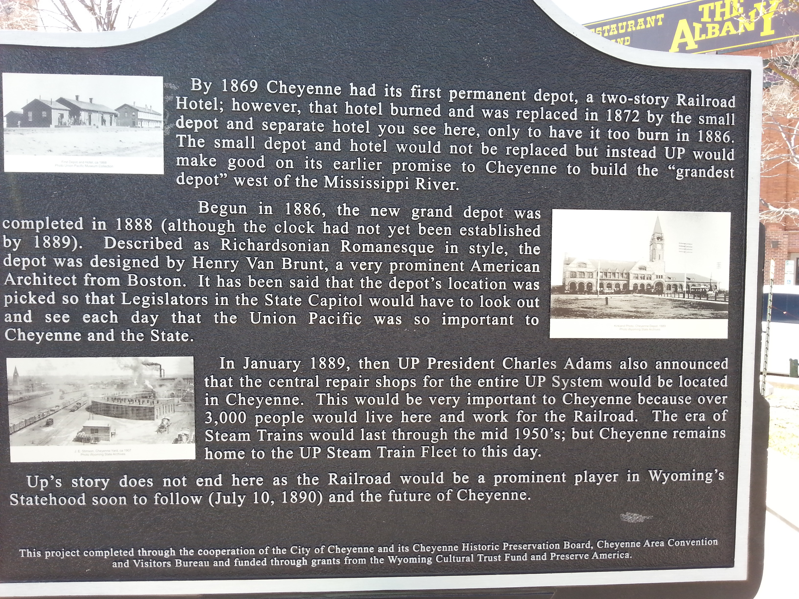
By 1869 Cheyenne had its first permanent depot, a two-story Railroad Hotel; however, that hotel burned and was replaced in 1872 by the small depot and separate hotel you see here [photo on marker], only to have it too burn in 1886. The small depot and hotel would not be replaced but instead UP would make good on its earlier promise to Cheyenne to build the “grandest depot” west of the Mississippi River.
Begun in 1886, the new grand depot was completed in 1888 (although the clock had not yet been established by 1889). Described as Richardsonian Romanesque in style, the depot was designed by Henry Van Brunt, a very prominent American architect from Boston. It has been said that the depot’s location was picked so that legislators in the State Capitol would have to look out and see each day that the Union Pacific was so important to Cheyenne and the state.
In January 1889, then UP President Charles Adams also announced that the central repair shops for the entire UP system would be located in Cheyenne. This would be very important to Cheyenne because over 3,000 people would live here and work for the railroad. The era of steam trains would last through the mid-1950s; but Cheyenne remains home to the UP Steam Train Fleet to this day.
UP’s story does not end here as the railroad would be a prominent player in Wyoming’s statehood soon to follow (July 10, 1890) and the future of Cheyenne.
The Burlington Routes Marker
1887-Present
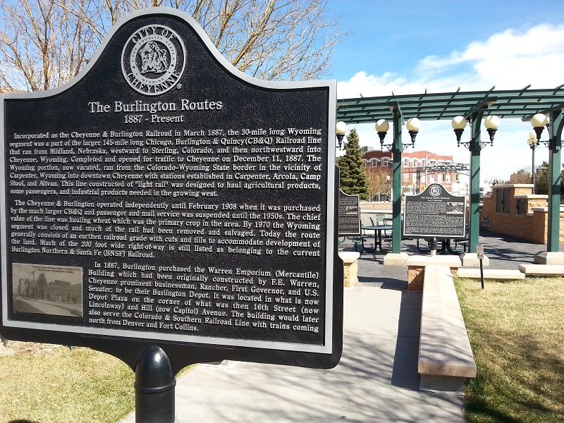
Incorporated as the Cheyenne & Burlington Railroad in March 1887, the 30-mile long Wyoming segment was a part of the larger 145-mile long Chicago, Burlington & Quincy (CB&Q) Railroad line that ran from Midland, Nebraska westward to Sterling, Colorado, and then northwestward into Cheyenne, Wyoming. Completed and opened for traffic to Cheyenne on December 11, 1887. The Wyoming portion, now vacated, ran from the Colorado-Wyoming state border in the vicinity of Carpenter, Wyoming into downtown Cheyenne with stations established in Carpenter, Arcola, Camp Stool, and Altvan. This line constructed of “light rail” was designed to haul agricultural products, some passengers, and industrial products needed in the growing west.
The Cheyenne & Burlington operated independently until February 1908 when it was purchased by the much larger CB&Q and passenger and mail service was suspended until the 1950s. The chief value of the line was hauling wheat which was the primary crop in the area. By 1970 the Wyoming segment was closed and much of the rail had been removed and salvaged. Today the route generally consists of an earthen railroad guide with cuts and fills to accommodate development of the land. Much of the 200-foot wide right-of-way is still listed as belonging to the current Burlington Northern & Santa Fe (BNSF) Railroad.
IN 1887, Burling purchased the Warren Emporium (Mercantile) Building which had been originally constructed by F.E. Warren, Cheyenne prominent businessman, rancher, first Governor, and U.S> Senator; to be their Burlington Depot. It was located in what is now Depot Plaza on the corner of what was then 16th Street (now Lincolnway) and Hill (now Capital) Avenue. The building would later serve the Colorado & Southern Railroad Line with trains coming north from Denver and Fort Collins.
Reverse of the Burlington Routes marker
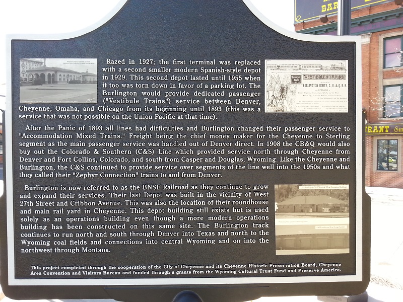
Razed in 1927; the first terminal was replaced with a second smaller modern Spanish-style depot in 1929. This second depot lasted until 1955 when it too was torn down in favor of a parking lot. The Burlington would provide dedicated passenger (“Vestibule Trains”) service between Denver, Cheyenne, Omaha, and Chicago from its beginning until 1893 (this was a service that was not possible on the Union Pacific at this time).
After the Panic of 1893 all lines had difficulties and Burlington changed their passenger service to “Accommodation Mixed Trains.” Freight being the chief money maker for the Cheyenne to Sterling segment as the main passenger service was handled out of Denver direct. In 1908 the CB&Q would also buy out the Colorado & Southern (C&S) Line which provided service north through Cheyenne from Denver and Fort Collins, Colorado, and south from Casper and Douglas, Wyoming. Like the Cheyenne and Burlington, the C&S continued to provide service over segments of the line well into the 1950s and what they called their “Zephyr Connection” trains to and from Denver.
Burlington is now referred to as the BNSF Railroad as they continue to grow and expand their services. Their last depot was built in the vicinity of West 27th Street and Cribbon Avenue. This was also the location of their roundhouse and main rail yard in Cheyenne. This depot building still exists but is used solely as an operations building even though a more modern operations building has been constructed on this same site. The Burlington track continues to run north and south through Denver into Texas and north to the Wyoming coal fields and connections into central Wyoming and on the into the northwest through Montana.