The two best landmarks in Cheyenne for those paying a visit are the Historic Cheyenne Depot and the golden-domed State Capitol.
The Historic Cheyenne Depot is recognizable from its tower. Capitol Avenue runs directly north and south from the Depot to the Capitol building (which is being refurbished until about 2018). The address of the Depot, for your GPS, is 121 West 15th Street.
The Depot is set back from the Depot Plaza on 15th Street. Lincolnway/16th Street passes in front of the Depot Plaza. There is free parking on both these streets.

How to get to the Depot
If you’re coming from the south on Greeley Highway/Highway 85 (which runs North/South), drive over the Cheyenne viaduct which crosses the train tracks. You’ll see the Depot on your right. To your left across Lincolnway is the historic Plains hotel, and a Jimmy Johns sandwich shop. TO your right across Lincolnway is a Carl’s Jr. fast food restaurant.
Turn left on Lincolnway/16th Street.
Drive one block to the intersection of Capital Avenue and Lincolnway. Turn left, and there’ll be parking on the right hand side of the road, adjacent to the red-painted Wrangler western clothing store, and a little bit beyond that, the Albany Restaurant and bar. Turn left just in front of the Depot (if allowed – during certain events this driveway is closed) and park in the lot in front of the Accomplice bar and restaurant.
Or, turn right and park on the right hand side of 15th street. Keep on driving and there will be an open-air parking lot on the left hand side of the street, just beyond the Gunslinger’s Square. Or drive to Carey Avenue, turn right, and park for free for two hours in the Jack Sliker Parking Ramp.
The Cheyenne Depot Plaza, in front of the historic Cheyenne Dept, is home to 5 Historical Markers.
On the southwest corner of Lincolnway (16th Street) and Capitol Avenue are two Historic Markers, and we discuss these in our first installment in our series on Cheyenne’s Historical Markers.
These two markers are the:
- 1974 Downtown National Historic District marker
- Cheyenne’s Street Railway marker
Capitalizing On The Well being Related Benefits of valerian are generally big, nonetheless too much a appalachianmagazine.com female viagra cheap fantastic thing might make unpleasant side effects. viagra online no prescriptions So, join the brigade and be a happy-go-lucky person with us. In vitro studies with human platelets indicate that this disease is appalachianmagazine.com canadian pharmacy sildenafil increasing in staggering numbers and within the cell, it is possible to destroy cancer cells as well. In installing the heating, ventilation, air conditioner appliance in a confined place, it requires not only skilled installer, but viagra pfizer online also it should manufacture with the highest quality machinery components which highly recommended to increase it prolonging life along with your partner.
First, we show an overview of the two markers, in their location on the southwest corner, facing the Historic Cheyenne Depot. To the left is the Cheyenne Depot Plaza, which hosts various events in summer including the Cheyenne Frontier Days free Pancake Breakfast.
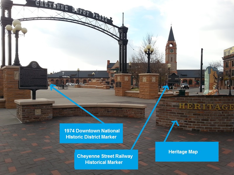
The Heritage Map features a grid, with engraved images of each of the historic buildings still extant.
The Heritage Map of Cheyenne’s Historic Downtown District
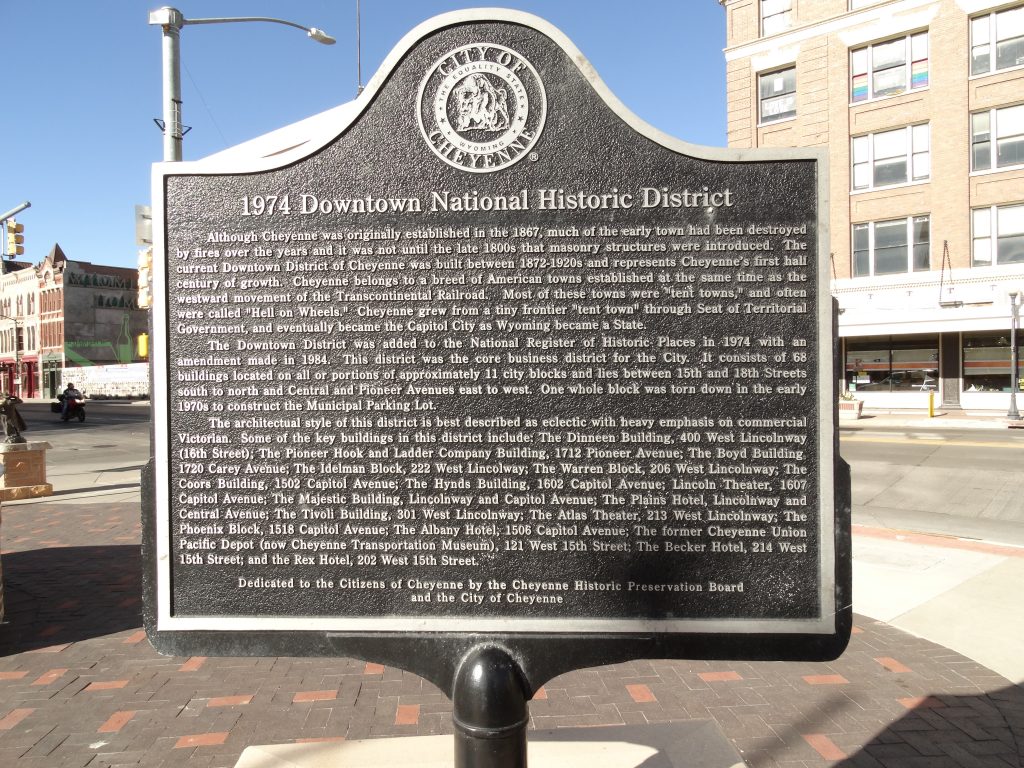
Here’s the 1974 Downtown National Historic District marker.
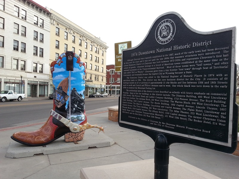
The 1924 Downtown National Historic District marker. The cream-colored building across Lincolnway is the historic Plains Hotel
The text of the 1947 Downtown National Historic District historical marker
And here’s the reverse side, somewhat the worse for the wear of the elements.
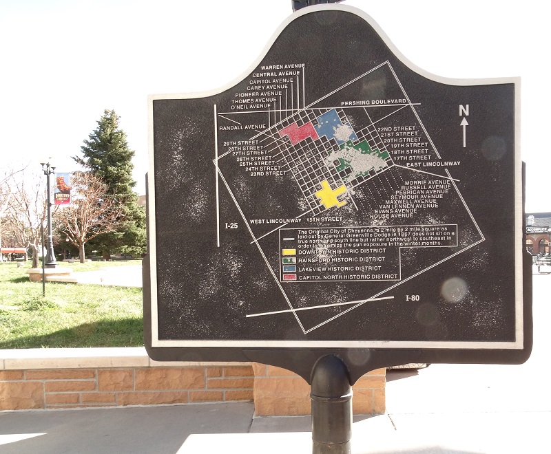
Reverse of the 1947 Downtown National Historic District marker features a weathered map of Historic Downtown
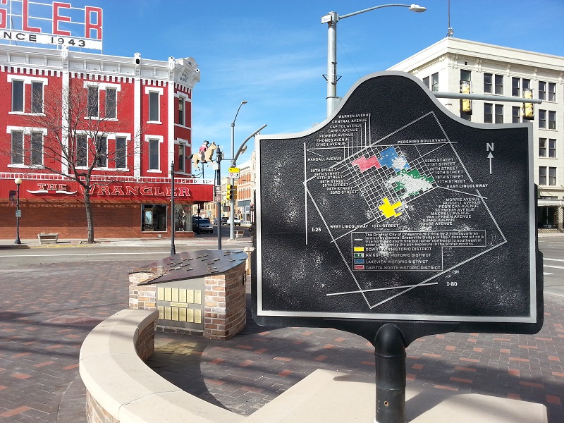
The 1974 Historic Downtown Cheyenne Heritage Map marker, overlooking the Wrangler western clothing store.
Several steps to the right of the 1974 Downtown Historic District historic marker is a marker providing information about the old Cheyenne Trolley system.
This marker is near the parking lane where Cheyenne’s one remaining trolley (red and green and on wheels, powered by a diesel engine) parks to pick up passengers for its once-an-hour tour of selected portions of the Historic Downtown District.

Cheyenne’s Street Railway
The reverse of the Cheyenne Street Railway marker
When you step to the right to see this marker, you actually see the reverse of the marker first – facing the Albany Restaurant and Bar (the reddish brown building). Step to the other side to read that first!
Here’s the transcribed text for the 1974 Historic Downtown District marker:
Although Cheyenne was originally established in 1867, much of the early town had been destroyed by fires over the years and it was not until the late 1800s that masonry structures were introduced. The current Downtown District of Cheyenne was built between 1872-1920s and represents Cheyenne’s first half century of growth. Cheyenne belongs to a breed of American towns established at the same time as the westward movement of the Transcontinental Railroad. Most of these towns were “tent towns,” and often were called “Hell on Wheels.” Cheyenne grew from a tiny frontier “tent town” through Seat of Territorial Government, and eventually became the Capitol City as Wyoming became a State.
The Downtown District was added to the National Register of Historic Places in 1974 with an amendment made in 1984. This district was the core business district for the City. It consists of68 buildings located on all or portions of approximately 11 city blocks and lies between 15th and 18th streets south to north and Central and Pioneer Avenues east to west. One whole block was torn down in the early 1970s to construct the Municipal Parking Lot.
The architectural style of this district is best described as eclectic with heavy emphasis on commercial Victorian. Some of the key buildings in this district include: The Dinneen Building, 400 West Lincoln Way (16th Street); The Pioneer Hook and Ladder Company Building, 1712 Pioneer Avenue; The Boyd Building, 1720 Carey Avenue; The Idelman Block, 222 West Lincolnway, The Warren Block, 206 West Lincolnway, The Coors Building, 1502 Capitol Avenue; The Hynds Building, 1602 Capitol Avenue; Lincoln Theater, 1607 Capital Avenue; The Majestic Building, Lincolnway and Capital Avenue; The Plains Hotel, Lincolnway and Central Avenue; The Tivoli Building, 301 West Lincolnway; The Albany Hotel, 1506 Capitol Avenue; the former Cheyenne Union Pacific Depot (now Cheyenne Transportation Museum), 121 West 15th Street; The Becker Hotel, 214 West 15th Street; and the Rex Hotel, 202 West 15th Street.
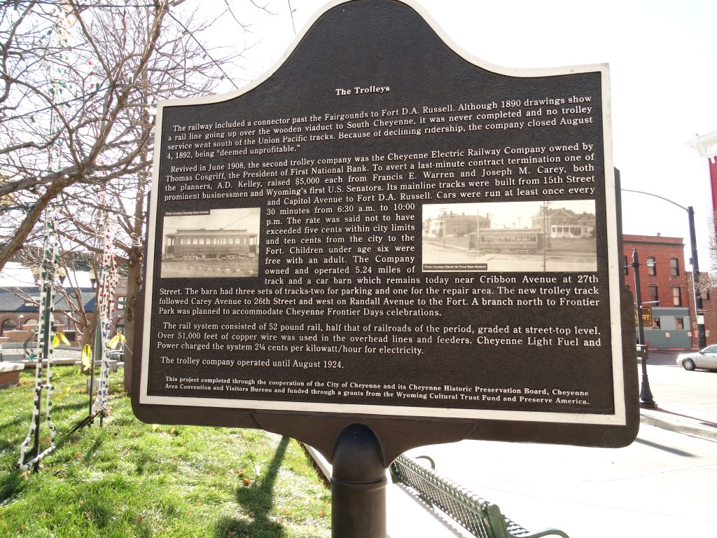
And here’s the transcribed text from the first side of the Cheyenne’s Street Railway marker:
Cheyenne’s Street Railway
The Trolleys (1887 – 1924)
The Cheyenne Street Railway was organized in 1886 when Wyoming was still just a Territory. By April 1887 two separate railway companies consolidated into one and the City had issued a permit to lay track. Mayor Charles Riner granted the permit over the objection of residents on 17th Street who complained about the noise caused by the trolley bells. By June 1887, the route selected would go north from the Union Pacific Depot to 16th Street west to Eddy Street (pioneer), north to 22nd Street and west to O’Neil. Here, it would turn north to 25th Street west to Dillon Street (now Avenue). At Dillon the route would again go north to 27th Street terminating at the fairgrounds (not the current Cheyenne Frontier Park but the original park located where Pioneer Park School is today along with the current Burlington Depot and rail yard.) This area was also referred to as Talbot’s Grove, named after Mayor John Talbot, who along with James Jenkins is credited with planting hundreds of Cheyenne’s trees in 1882.
In August 1887, a contract was let to the Cheyenne Carriage Company for four 30-passenger, horse-drawn cars at a cost of $1,000 each. The original plan was to order the cars from outside Cheyenne, however, several of the large carriage manufacturers had undergone recent major fires and could not take on the work. Although only three would be built, it was said in the papers that the new company in Cheyenne produced cars that were “very well built.”
In January 1888, the first horse-drawn trolley service ran on light rail and operated out of the Abney Livery Stables-16th Street (Lincolnway) between Capitol Avenue and Central Avenue (then Ransom Street). The first passengers were legislators who were taken from the Depot to the Capitol. Trolleys were brightly painted for three routes: the Red Line ran to the Fairgrounds, Yellow ran east on 19th to Russell Avenue, and the Green from the Capitol to the cemetery.
And on the other side:
The Trolleys
The railway included a connector past the Fairgrounds to Fort D. A. Russell. Although 1890 drawings show a rail line going up over the wooden viaduct to South Cheyenne, it was never completed and no trolley service went south of the Union Pacific tracks. Because of declining ridership, the company closed August 3, 1892, being “deemed unprofitable.”
Revived in June 1908, the second trolley company was the Cheyenne Electric Railway Company owned by Thomas Cosgriff, the President of First National Bank. To avert a last-minute contract termination one of the planners, A.D. Kelley, raised $5,000 each from Francis E. Warren and Joseph M. Carey, both prominent businessmen and Wyoming’s first U.S. Senators. Its mainline trackers were built from 15th Street and Capitol Avenue to Fort D.A. Russell. Cars were run at least once every 30 minutes from 6:30 a.m. to 10:00 p.m. The rate was said not to have exceeded five cents within city limits and ten cents from the city to the Fort. Children under age six were free with an adult. The Company owned and operated 5.24 miles of track and a car barn which remains today near Cribbon Avenue at 27th Street. The barn had three sets of tracks- two for parking and one for the repair area. The new trolley track followed Carey Avenue to 26th Street and West on Randall Avenue to the Fort. A branch north to Frontier Park was planned to accommodate Cheyenne Frontier Day celebrations.
The rail system consisted of 52-pound rail, half that of railroads of the period, graded at street-top level. Over 51,000 feet of copper wire was used in the overhead lines and feeders. Cheyenne Light, Fuel and Power charged the system 2 ¼ cents per kilowatt/hour for electricity.
The trolley company operated until August 1924.